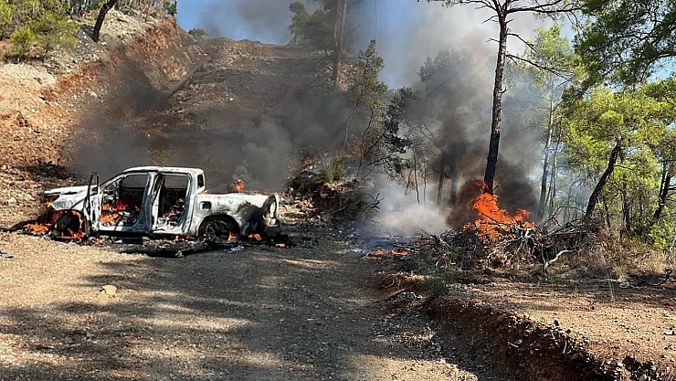

Strong storm warning from meteorology: Weather in fire regions
While forest fires continue in Muğla, Antalya, Balıkesir, and İzmir, meteorology issued a strong wind warning in the form of a storm.
In the fires in Fethiye and Seydikemer, the severe wind, which is sometimes effective, complicates interventions and causes the fire to spread rapidly.
METEOROLOGICAL OUTLOOK
According to the latest evaluations by the General Directorate of Meteorology; the northeastern regions of our country are expected to be partly cloudy, locally very cloudy; the coasts of the Eastern Black Sea and the northeast of Eastern Anatolia as well as around Artvin and Ordu will have local showers and thunderstorms, while other areas will be slightly cloudy and clear. Winds are expected to blow strongly (40-60 km/h) from the northern directions in Marmara, Aegean, southern and eastern parts of Central Anatolia, and inner parts of the Mediterranean, with occasional short-term storms (50-70 km/h, gusts up to 80 km/h) in the southwest of Marmara, northern Aegean coasts, and inner parts of the western Mediterranean.
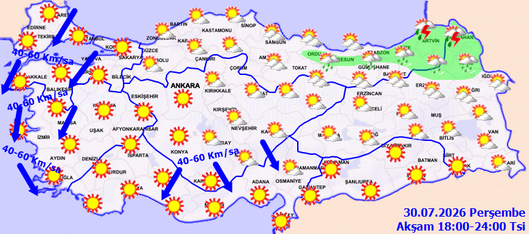
TEMPERATURE: No significant change is expected in temperatures, which are generally around seasonal norms nationwide.
WIND: Winds will generally be from northern directions, light to moderate from southern directions in the southeast parts of the country, sometimes moderate, strong (40-60 km/h) from northern directions in Marmara, Aegean, southern and eastern parts of Central Anatolia, and inner Mediterranean, and occasional short-term storm-like winds (50-70 km/h) are expected in the southwest of Marmara, northern Aegean coasts, and inner western Mediterranean.
WARNINGS
STRONG WIND AND STORM WARNING: As winds are expected to blow strongly and in storm form (50-70 km/h, gusts up to 80 km/h) from the north and northeast (poyraz) directions in the southwest of Marmara and northern Aegean, necessary precautions should be taken against adverse effects such as tree and pole fallings, roof blow-offs, and transportation disruptions.
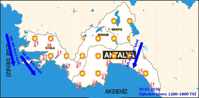
METEOROLOGICAL OUTLOOK FOR MUĞLA AND ANTALYA
Clear weather is expected.
TEMPERATURE: A decrease of 1 to 3 degrees is expected in coastal areas, and 2 to 4 degrees in inner parts.
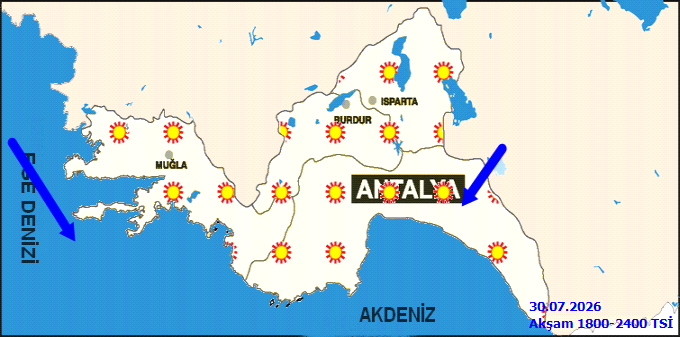
WIND: Winds are expected from northern directions at moderate intensity, occasionally strong, and locally stormy.
WARNINGS
Wind is expected to blow in storm form from northern directions in the eastern inner parts of Antalya.
Winds in seas are expected to blow in storm form from northern and western directions in Antalya Gulf starting from night hours.
Precautions should be taken against possible adverse effects caused by high temperatures and low humidity, and occasionally high humidity in coastal areas.
Expected Weather by District Minimum
(°C) Maximum
(°C)
Muğla Clear 36
Bodrum Clear 38
Dalaman Clear 39
Datça Clear 37
Fethiye Clear 39
Kavaklıdere Clear 32
Köyceğiz Clear 41
Marmaris Clear 38
Milas Clear 40
Ortaca Clear 39
Ula Clear 37
Yatağan Clear 39
Seydikemer Clear 39
ATTENTION TO STRONG WIND AND STORM IN SOUTHWEST MARMARA AND NORTHERN AEGEAN!
Start-End Time
30.07.2026 11:00 - 30.07.2026 23:59
General Situation
According to the latest evaluations, the winds expected in northwest parts tomorrow (Thursday) are anticipated to blow strongly and in storm form (50-70 km/h, gusts reaching 80 km/h) from northern and northeastern (poyraz) directions in the southwest of Marmara and northern Aegean. Precautions should be taken against hazards such as tree and pole fallings, roof blow-offs, and transportation disruptions.
STORM EXPECTED IN OUR SEAS (MARMARA AND MEDITERRANEAN)!
Expected Event
Storm
Location
In the southern Marmara, winds are expected to blow from northern and northeastern directions with force 6 to 8 (50-75 km/h) as storm form after noon tomorrow (30.07.2026). The storm is expected to lose effect by night.
In the western part of Antalya Gulf, winds are expected to blow from northern directions with force 6 to 8 (50-75 km/h) as storm form starting from the early hours tomorrow (30.07.2026). The storm is expected to lose effect after noon the same day.
In the western Eastern Mediterranean (Anamur-Silifke), winds are expected to blow from northern directions with force 6 to 8 (50-75 km/h) as storm form starting from the early hours tomorrow (30.07.2026). The storm is expected to lose effect after noon the same day.
Start-End Time
30.07.2026 12.00-30.07.2026 23.00
STORM EXPECTED IN OUR SEAS (AEGEAN AND WESTERN PART OF WESTERN MEDITERRANEAN (ANTALYA GULF))!
Expected Event
Storm
Location
In northern Aegean, winds are expected to blow from northern and northeastern directions with force 6 to 8 (50-75 km/h) as storm form after noon tomorrow (29.07.2026). The storm is expected to lose effect after noon Saturday (31.07.2026).
In southern Aegean, winds are expected to blow from northern and northwestern directions with force 6 to 8 (50-75 km/h) as storm form after noon tomorrow (29.07.2026). The storm is expected to lose effect after noon Saturday (31.07.2026).
In the western part of Western Mediterranean (Antalya Gulf), winds are expected to blow from northern directions with force 6 to 8 (50-75 km/h) as storm form starting from early hours tomorrow (29.07.2026). The storm is expected to lose effect starting from noon on the same day.
Start-End Time
29.07.2026 03.00-31.07.2026 14.00
Severity of the Event
Storm